socioeconomic Impacts of the Black Summer
Introduction
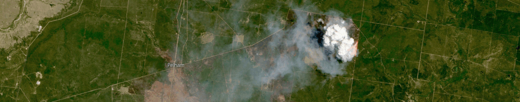
The 2019-2020 Australian bushfires were one of the most destructive environmental events in history, burning millions of acres, destroying thousands of homes, and producing smoke that affected cities for weeks. This season was a major point in Australia’s fire history, fueled by record breaking conditions of wind and temperatures allowing flames to rapidly spread. During this crisis, major cities experienced hazardous air quality levels for weeks, while rural areas faced direct threats from the fast moving fire. Although the scale of the fire effects are well recorded, how the fires impacted urban versus rural populations differently was less understood. This project aims to investigate how these fires shaped unequal impacts, arguing that rural communities faced severe environmental and safety risks due to their proximity to the burn areas. Understanding these differences is essential for improving long term planning and developing targeted disaster response strategies.
The analysis relies on a dataset generated through NASA’s remote sensing technology, recorded by the MODIS C6 satellite instrument across the six month period of fire activity from August 1, 2019 to January 11, 2020. The original source of the dataset was received by NASA’s Earthdata database, which includes data from around the world collected by NASA’s satellites including location of the fires by latitude and longitude, brightness, scan and track, acquisition date and time, and confidence values to show the reliability of each detection. In order to contextualize this data, we merged the fire data with Australian Bureau of Statistics State and Section of State shapefiles, allowing us to classify each fire event as occurring within an urban, suburban or rural region. Along with this qualitative data, we also reviewed a collection of articles examining the effects on air quality, health, and community responses across rural and urban regions. Using insights from both the dataset and the literature allows us to fully understand how the fires’ impacts differ across population types.
Timeline
Research Questions
1
How were human populations in rural and urban communities affected by the 2019-2020 Australian wildfires?
2
What environmental consequences resulted from the 2019 – 2020 Australian wildfires in urban and rural areas?
3
How did fire location and intensity contribute to unequal impacts across urban and rural communities?
Literature Review
Overview
Existing scholarship on the 2019–2020 Australian “Black Summer” fires consistently emphasizes the extraordinary scale of environmental, health, economic, and social damage, yet differs in how these impacts manifested across urban and rural regions. While urban-centered studies often highlight air and water quality deterioration, rural-focused research points to infrastructural strain and direct exposure to fire fronts. Despite this breadth of work, few scholars directly compare these impacts across urban and rural areas, and even fewer integrate demographic data to explain how patterns of fire activity shaped unequal experiences during the crisis.
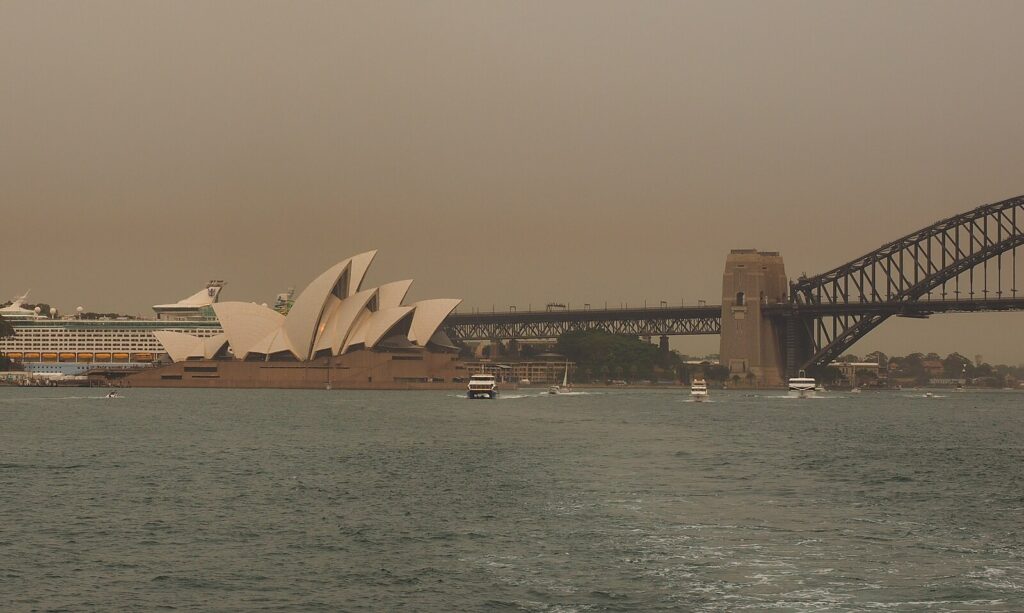
Urban focused research demonstrates the severe air-quality decline in cities such as Sydney and Melbourne, documenting spikes in respiratory hospitalizations, premature deaths, and reduced visibility (Nguyen 2021; Ryan 2021; Morgan 2010). Several studies also analyze the extreme emissions produced during the fires, using satellite data to trace CO and NO2 plumes across densely populated metropolitan corridors (Wan 2023). Additional work links rural burning to urban vulnerabilities by showing how fire damage to regional catchments reduced water supply reliability for cities like Melbourne (Khastagir 2023). Collectively, these studies reveal how environmental hazards originating in rural zones had far-reaching effects on urban systems.
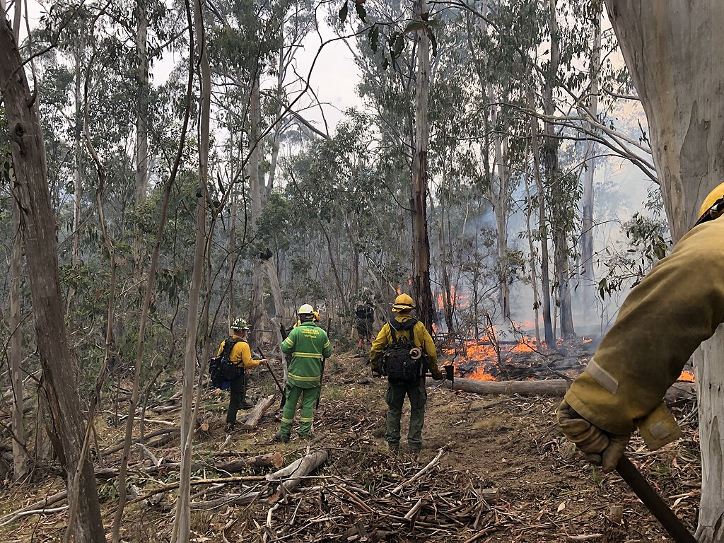
A parallel body of literature examines the acute and long-term burdens borne by rural communities. Scholars document disproportionate property loss, displacement, livestock deaths, and limited emergency response capacity due to close proximity to burn zones (Filkov 2020; Ahmed 2023). Qualitative research highlights the psychological toll on rural residents, particularly farmers, who faced prolonged trauma, livelihood instability, and social isolation (Kruk 2024). Other studies explore rural householders’ heightened perceptions of threat and their complex evacuation decision-making (Adedokun 2025). Economic analyses further show uneven post-fire labor outcomes, with reconstruction generating employment gains in rural, male-dominated sectors while urban service industries experienced losses (Hickson 2022). Taken together, this literature demonstrates that rural communities endured more direct and immediate consequences than their urban counterparts.
Discrepancies
While scholars broadly agree on the severity of Black Summer, they diverge in their explanations of how these impacts were distributed. Urban centered studies frequently emphasize air pollution, health outcomes, and environmental hazards that spread well beyond burn areas (Ryan 2021). In contrast, rural-focused research stresses infrastructural strain, mental health burdens, and socioeconomic vulnerability arising from direct exposure to fire fronts (Filkov 2020). Some sources depict strong institutional capacity and community social capital during the fires (Ahmed 2023), whereas others identify inadequate national coordination, inconsistent data collection, and policy limitations that left many, and mostly rural regions exposed (Bowman 2020). These differences highlight ongoing debates about whether government response or community resilience played the dominant role in shaping recovery outcomes.
Another discrepancy appears in how scholars conceptualize consequences. Urban studies often frame impacts in terms of short term pollution spikes and indirect hazards, whereas rural scholarship tends to focus on psychological, agricultural, and economic disruptions. Health research also presents varied findings, with some work emphasizing acute respiratory effects in cities (Morgan 2010) and others showing severe stroke and cardiovascular risks among rural populations more directly exposed to smoke plumes (Hasnain 2024). These contradictions reflect the complex geography of the Black Summer fires and the differing ways environmental harm magnifies existing regional inequalities.
Commonalities
Despite these divergences, the literature demonstrates broad agreement that the Black Summer fires were unprecedented in intensity and represent a turning point in Australia’s climate disaster trajectory. Almost all scholars link the fires to extreme weather conditions, climate change, and the growing likelihood of future mega fire seasons (Nolan 2020). Many studies also agree that the fires exposed deep gaps in governance, risk communication, and national fire monitoring capabilities, reinforcing the need for more coordinated, data driven policy interventions (Haque 2023).
Across disciplines, authors also emphasize that both urban and rural communities suffered significant environmental and social impacts. However, these health burdens, economic losses, and social disruptions varied substantially by location, demographics, and proximity to burn areas (Hickson 2022; Jetten 2021). Another widely shared theme is the importance of community resilience, social capital, and mental-health support systems in shaping post-disaster outcomes (Kruk 2024; Ahmed 2023).
Finally, several studies call for further research that integrates spatial, demographic, and environmental data to better understand how disasters like Black Summer affect populations unevenly. Analysis revealed that existing wildfire scholarship often overlooks comparative regional analysis and lacks health, economic, and social perspectives (Haque 2023). Few works directly compare urban, suburban, and rural experiences, leaving a significant gap in understanding how geographic context shapes vulnerability during large-scale fire events.
Significance
This project is important because it addresses a gap in existing research, the lack of a combined. Data-driven comparison of how the 2019-2020 bushfires affected different urban, subrural, and rural populations. By merging NASA’s fire detection data with regional classifications, our project offers a clearer picture of where fires occurred and which communities were most directly exposed. We are working on understanding rural-urban disparities because we want to find out how geographic location and the nature of the environment influences risks and community level consequences, in order to help others understand the unequal vulnerabilities that major climate disasters create. In doing so, our project contributes to broader questions about climate resilience, environmental justice, and disaster preparedness.
Visualizations

Fire Count Distribution
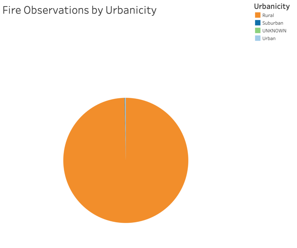
The fire observations pie chart displays the amount of satellite observations measured in urban, suburban, and rural areas. This chart clearly displays the extreme differences in the presence of fires in rural areas in comparison to urban and suburban communities. The vast majority of the fires occurred in rural areas. This chart allows us to conclude that the direct effects of the fires in rural areas vastly outnumber the effects seen in urban areas.
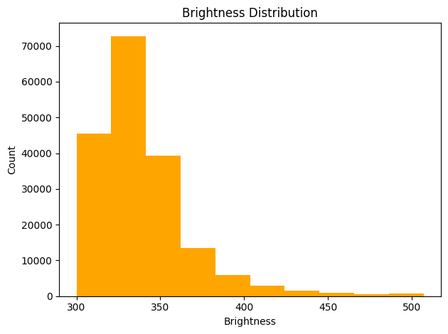
Brightness Distribution
The brightness histogram reveals a right-skewed distribution, where most fire detections fall within a moderate brightness range while fewer events reach extremely high values. This pattern means that the majority of fires in the dataset are relatively low to moderately intense, with only a smaller number of high-energy fire events detected. The natural skew is expected in wildfire datasets, where intense firestorms are rarer than smaller-scale burns. The spread of data could also mean there is variability in combustion conditions across the region.
Radiative Power Distribution
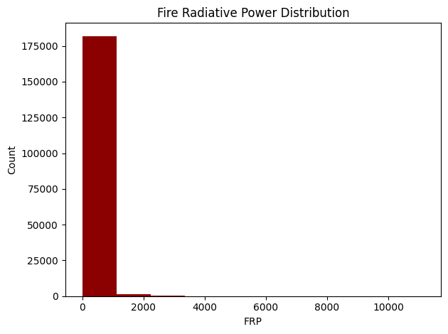
The histogram displays a concentration of values near the lower end, with a long tail tapering off into higher radiative power levels. FRP is a proxy for fire intensity and biomass consumption rate, so this distribution shows that most fires are burning with low to moderate strength. However, the presence of a tail with higher FRP values confirms that a subset of fires is significantly more intense. These high FRP events are critical for environmental impact analysis because they contribute disproportionately to the impact of fire.
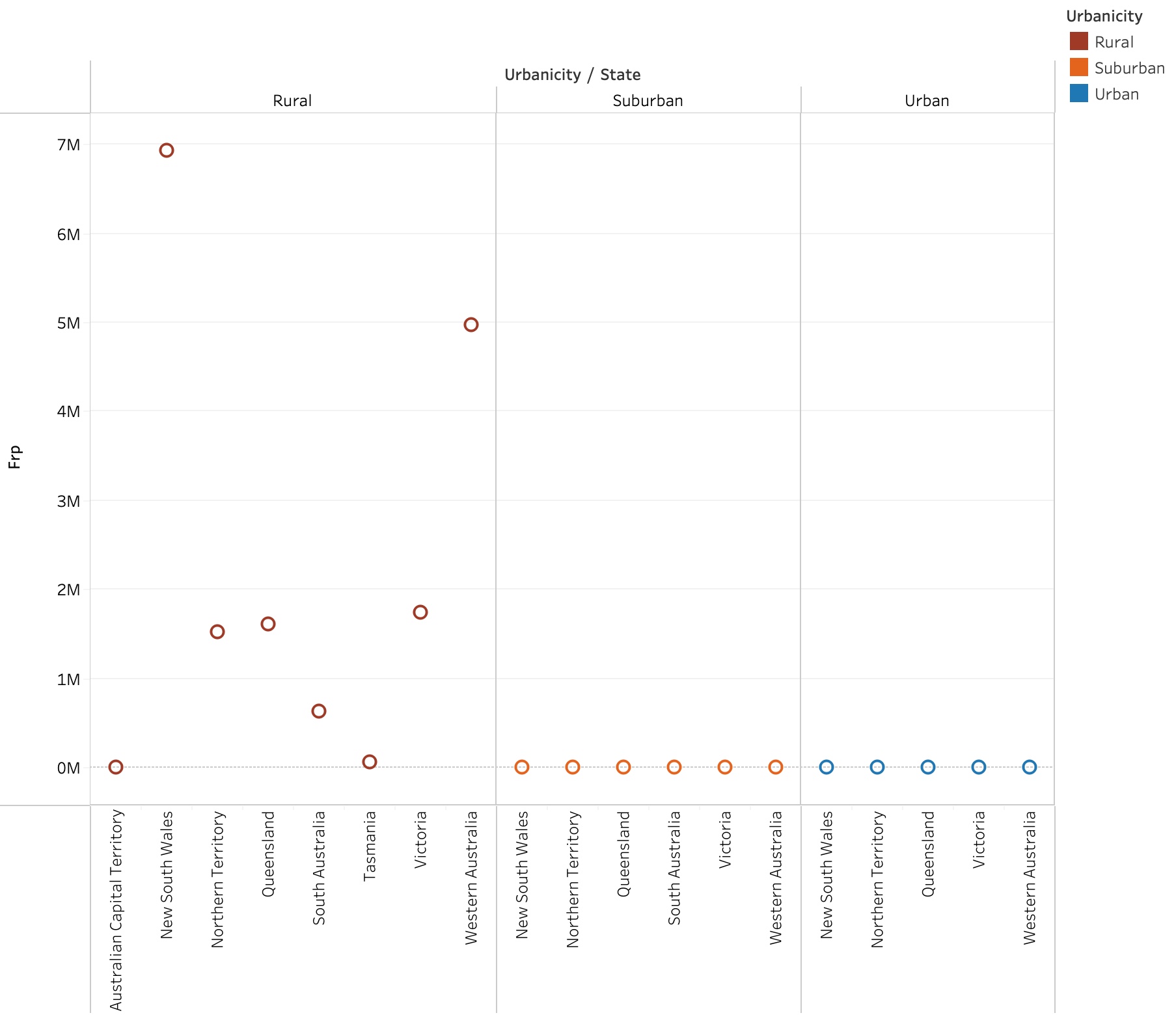
Fire Intensity by state and urbanicity
The scatterplot of fire intensity by state and urbanicity shows that fire intensity is significantly higher in rural areas compared to suburban and urban areas across all states. Rural areas experienced the most intense fires due to having more open land and conditions that allow fires to spread. This pattern is especially clear in the Australian Capital Territory, New South Wales, and Western Australia.
Brightness vs. FRP
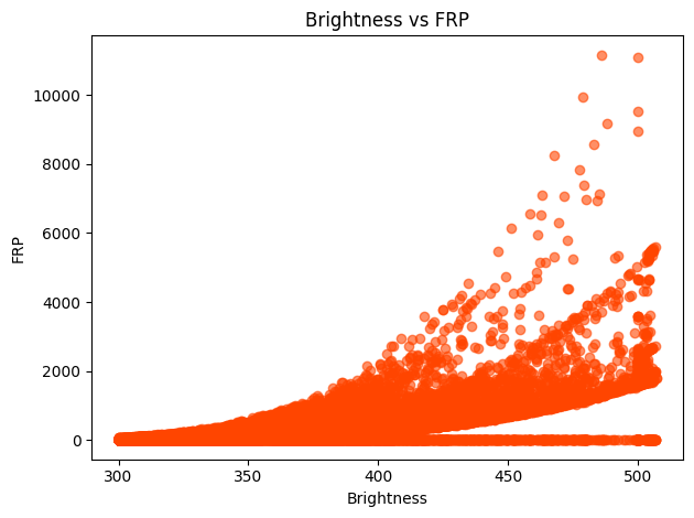
The scatter plot comparing brightness and fire radiative power shows a clear positive relationship: as brightness increases, so does FRP. This makes physical sense because hotter or more intense fires emit more thermal energy, which the satellite records both as increased pixel brightness and higher radiative power. Although the relationship is not perfectly linear, the general trend shows that brightness is a strong proxy for estimating fire intensity within this dataset. The dispersion also highlights that not all bright fires correspond to extreme FRP values, hinting at variations in fire area or combustion efficiency.
Argument
RQ Analysis
1
How were human populations in rural and urban communities affected by the 2019-2020 Australian wildfires?
Based on our findings, we can see clear differences in how rural and urban communities were affected from the 2019-2020 bushfires. From the scatterplot of fire locations, we can see a dense cluster of fire detections near smaller towns and agricultural areas, indicating high proximity to flames. This tight cluster indicates that rural communities were directly exposed to these fires, consistent with the articles that documented property destruction and loss in these areas. On the other hand, although some major cities such as Sydney and Melbourne were not located within these immediate zones, they did experience other issues directly related to the fires such as prolonged air quality risks and visibility restrictions due to smoke. Our dataset justifies this pattern, as although none of the fire patterns overlap in these urban populations, the density of the fire activity in regions surrounding displays how the smoke travels to these other regions. A limitation of our dataset is that it does not include any exact numbers regarding how many people were affected. However, from the fire patterns and literature, we can conclude that rural areas faced immediate threats while urban areas experienced secondary effects from the movement of smoke.
2
What environmental consequences resulted from the 2019 – 2020 Australian wildfires in urban and rural areas?
The environmental consequences from the 2019-2020 fires were unequal, with rural populations being affected the most. From both the brightness histogram and the fire radiative power histogram, we can see that although most of the events were low to moderately intense, there were still many high intensity fires that had strong effects on rural communities leading to vegetation loss, habitat destruction, and soil degradation. Additionally, many of these fires contributed to carbon emissions, biodiversity loss, and watershed disruption causing many losses too the rural areas. On the other hand, urban areas experienced much less direct environmental loss. Their primary consequence was air quality and polluted water, which were once again secondary effects. A limitation to this dataset is that the data ends in January 2020, meaning that we cannot study long term environmental effects using just the data.
3
How did fire location and intensity contribute to unequal impacts across urban and rural communities?
From the combination of the spatial and intensity visualizations, we can see how the geography of these fires led to unequal impacts across urban and rural communities. The clear positive relationship between brightness and FRP, along with the higher concentration of fire detections in rural areas shows how intense these fires were especially in populations that were directly in this area. This proximity along with having fewer emergency response resources was a major issue, as they were constantly being affected by these large scale fires. Urban populations had benefited from stronger infrastructure, medical support, and emergency communication systems showing how even though they had second hand effects, they had better resources to deal with the situation. A limitation of our dataset was by not having enough information about emergency preparedness or response methods, which is why we relied on the literature to pull everything together and better understand how these factors shaped our overall interpretation.